Harvard professor John Huth is an experimental particle physicist who was on the team that discovered the Higgs boson. He teaches an undergraduate course on primitive navigation at the university, and is the author of The Lost Art of Finding Our Way. The professor, whose love for the outdoors takes him beyond the pale of cellphone coverage, spoke to The Download about his digital habits.
What wakes you up each morning?
Changing light levels at dawn wake me during spring, summer, and autumn. When days get shorter in the winter I use the alarm on my wristwatch if I need an early-wakeup.
What object of technology would you feel lost without?
My wristwatch. I have a highly constrained schedule at work. I do a lot of video-conferencing to CERN in Geneva. In an international collaboration, people coordinate to meet and discuss results virtually. So my watch and my e-calendar help me keep track of my appointments here and across multiple time-zones.
Do you use social media as a scientist?
On Quantum Diaries, particle physicists blog about work and life. When the discovery of the Higgs boson was announced in 2012, I was asked to write about “what it all meant.” On my daily tram ride to CERN, I was reading The Innocents Abroad by Mark Twain. I wrote a post titled “The Celebrated God Particle” as if the writer had reincarnated to report on the discovery. Too much reporting on science is over the top, so I am snarky and skeptical.
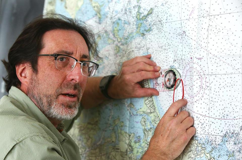
What are some tech tools you’d take on a backpacking trip?
I’m mostly a map and compass guy.
I find Hi-Def Radar, an app, which gives me a radar image of weather conditions, quite helpful. I don’t want to be on an exposed ridge in a thunderstorm.
Sometimes, I use a satellite tracker, SPOT Gen3, which broadcasts my GPS coordinates periodically to people on an email list. That way they know I’m safe. The device also has an SOS feature.
And while you are out kayaking?
Sea kayaking carries more risks than hiking, so I like to have back-ups. One ‘must have’ is a portable, waterproof VHF transceiver which allows me to make distress calls. Thus far, I’ve only used it to alert boats when I’m crossing a busy channel, especially in foggy weather.
I use stars and planets in the night sky to orient myself. Although I know the positions of major stars, planets can be an issue. (The word “planet” is derived from the Greek word for “wanderer,” and they do tend to wander.) So, I consult Neave, an online planetarium, to see where the planets are in relation to the constellations.
Last summer, to learn the secrets of a “wave pilot,” you monitored the progress of a canoer from Marshall Islands who took his navigational cues from nature.
The voyage from Majuro, where the capital of the Marshall Islands is located, to another atoll, Aur, which is some 150 miles north, was across a fairly rough channel.
We used a Garmin ForeTrex waterproof GPS to document where we were and to compare notes with the native navigator. As it turns out, he was amazingly correct in figuring out our location, without use of anything other than his wits.
If things had gone horribly wrong – if the wind had dropped out and if we drifted at the mercy of the currents, we probably would have gone to the GPS to get landfall. Fortunately, this didn’t happen.
I took a Brunton portable weather station. We also had gadgets designed to start a search-and-rescue operation if any of us fell overboard.
So mostly no GPS for you on land?
I’d rather look at a map where I can get a larger sense of where landmarks and roads are in relation to a route I’m taking. If I get lost, I’ll go back to the map to figure out where I am.
I also enjoy asking for directions, not just because it gets me where I’m going, but it also gives an interesting insight into how people think about finding their way. I just find that interactions with the environment and people are fuller when we eliminate too much high-tech.